Top Earthquake Risk Cities in the U.S. -- S - Z
Since rankings tend to vary from site to site and year to year, but the highest earthquake risk cities tend to remain in the rankings, the cities are listed in alphabetical order. In the S through Z we'll look at San Francisco, Salt Lake City, Seattle, Tulsa, Washington D.C., and Wichita.
For reference, here's the USGS earthquake hazard map.

San Francisco, California
Overall, California has a greater than 99 percent probability of one or more magnitude 6.7 or larger earthquakes occurring by 2037. However, while the probability is greater for Southern California, Northern California’s chances are 93 percent for a magnitude 6.7 earthquake during that time frame. A magnitude 7.0 has a 68 percent probability, while a 7.5 has only a 15 percent chance of occurring.
Focusing on the San Francisco area, the USGS gives the region a 63 percent chance of a magnitude 6.7 or larger happening by 2037 (UCERF3: A new earthquake forecast for California's complex fault system).

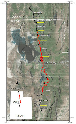
Salt Lake City, Utah
The capital of Utah, Salt Lake City, sits on one section of the 240-mile-long Wasatch Fault, and nearly 80 percent of Utah’s population lives within fifteen miles of the fault. Earthquakes of magnitude 7.0 and larger have historically struck at some point along the fault about every 350 years. The last definitively large quake happened around 600 years ago, with another one possibly as recent as 400 years ago. In either case, the area is primed for another big one. Recent projections have estimated the likelihood of a magnitude 6.75 or higher earthquake over the next 50 years is 43 percent.
Seattle, Washington
California usually takes the spotlight when it comes to earthquake risks, but in recent years, the Cascadia Subduction Zone has been stealing some of the thunder.
With more than 4 million people in and around the Seattle area, a lot of scientists may be more worried about that metropolitan region than any other.
The odds of a big, magnitude 8.0 to 8.6 “Cascadia earthquake happening in the next fifty years are roughly one in three” (The Really Big One). But the Cascadia Subduction Zone can produce even megathrust earthquakes, from 8.7 to 9.2, and the chances of that happening are one in ten.
The frequency of a magnitude 6.0 or larger earthquake is about every 30 to 50 years. The frequency of a megathrust quake varies from 200 to 1,500 years. Lack of data for the Seattle Fault has left earthquake interval estimates to vary from 200 to 15,000 years.
For the Seattle Fault, the most recent earthquake was about 1,100 years ago. The fault is estimated to be able to produce a magnitude 7.5 event.
A large tremor on the Seattle Fault could cause 5,000 to 30,000 landslides in the region, depending on soil moisture conditions when the quake strikes. The quake could also produce a 16-foot tsunami that would strike within seconds and flood the area within five minutes. Over 1,100 unreinforced masonry buildings in the city would be subject to collapse. Like in other earthquake-risk areas, fires will break out, and many of the roads, bridges, and other infrastructure, including water and electricity, will be damaged (Seattle Emergency Management, Earthquake).
Tulsa, Oklahoma
Like Oklahoma’s capital city, Tulsa has a population of more than 400,000 at risk of earthquakes.
As in other parts of Oklahoma, the earthquake risk is largely due to induced seismicity. A 2015 Stanford University study of earthquakes and wastewater injection showed a “clear relation” and that Oklahoma was “‘almost certain’ to have at least one damaging earthquake in the next five years, with heightened risks of a large quake probable to endure for a decade” (Oklahoma 'almost certain' for another damaging earthquake; risks to be elevated for next decade). The reason the heightened risk is not expected to continue much beyond that is due to regulatory caps on how much wastewater can be injected back into the ground. The study noted the “state’s 180-day moving average of magnitude-2.8 or greater quakes peaked at approximately 4.5 per day in summer 2015, tailing off to about 2.3 a day this fall [2016].”
Prior to 2009, the average number of magnitude 3.0 or greater earthquakes in the state was one per year. There were about 900 of these size quakes in 2015.
Washington, D.C.
In 2011, a magnitude 5.8 earthquake in the Virginia Seismic Zone damaged buildings and other structures in the D.C. area. It was estimated almost a third of the U.S. population felt the earthquake. The geology of the area causes an earthquake to be felt over a larger region, as has been previously mentioned. As a comparison, a 2010 magnitude 7.2 rupture in Baja California was felt over a similarly sized area as the 2011 Virginia quake ( Seismic Risk in Eastern U.S. May Be Higher Than Previously Thought).
While the USGS hazard map indicates a lower risk in the D.C. area, analysis of the 2011 Virginia quake “indicates that Washington DC and other affected population centers could be at a higher risk of major ground movement than previously recognized”.
An interesting finding came after the 2011 Virginia earthquake. Previously, scientists believed a magnitude 5.8 earthquake couldn’t possibly trigger landslides further away than about 37 miles (60 km). But the quake caused rockfalls at least 152 miles (245 km) away—more than four times the distance scientists believed was possible.
Wichita, Kansas
The risk of a damaging earthquake in northern Oklahoma and southern Kansas, where Wichita is located, was estimated in 2016 to be 10 to 17 percent. Because building codes in Wichita were not as earthquake resilient as those in California, a lower magnitude earthquake has the potential to cause comparable damage as a higher magnitude quake in the Bay Area of California. For further comparison, Los Angeles County has a 2 to 5 percent risk of a damaging earthquake (Survey: Risk of damaging quake greater in southern Kansas than southern Calif.). Please note the risk of a “damaging earthquake” is not necessarily prediction of a high-magnitude quake in the Wichita area, just the potential for damage using the Modified Mercalli Intensity Scale.
As we’ve discussed, the thousands of small earthquakes striking northern Oklahoma and southern Kansas over the past several years have been blamed on wastewater from fracking operations being injected deep underground. Limits on locations and disposal amounts have been put into place in an attempt to reduce the earthquake hazard.


Comments
Post a Comment