Seismic Faultlines, short novel

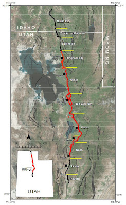
Shameless plug for a novella I wrote and published this summer. Seismic Faultlines , is a short novel based on a massive earthquake striking the Salt Lake Valley in Utah (on the Wasatch Fault). I drew on personal experience from a 7.9 quake when I was 12, and also from a bunch of earthquake and preparedness research (including a book I wrote several years ago, Earthquake! What, Where, and How to Prepare ). While most scientists think the Wasatch Fault segments can only produce up to a 7.5 magnitude quake, what if they're wrong? What if it's much worse? Here's the Seismic Faultlines book description from the Amazon page: Utah is overdue for a big earthquake. The Wasatch Fault has a 43% chance of 6.75 or greater quake in the next 50 years. What happens when the Big One is a thousand times worse than expected? San Andreas may steal the spotlight, but when a less famous fault zone in Utah releases an earthquake 1,000 times stronger than thoug...