Posts

Showing posts from December, 2021

Earthquake Hazards: Tsunami

Image
 A tsunami is a high sea wave. It can travel hundreds, even thousands, of miles across the ocean. While over deep water, they can be difficult to detect due to their large wavelengths, which can take 20 to 30 minutes for it to cycle and may only have a few feet of height. As the tsunami passes through shallower water, wave shoaling compresses the wave, making it slower and taller. Tsunami wave rises high and quick over steep coastline Tsunamis can be caused by vertical displacement of the seabed due to an earthquake. They can also be caused by a landslide crashing into the water, and that landslide could have been caused by an earthquake. A December 2004 Indian Ocean earthquake of magnitude 9.1–9.3 caused tsunamis along the coasts of the Indian Ocean. The tsunami waves killed 230,000 to 280,000 people, with heights up to 100 feet. The earthquake was the third largest since recording started in 1900, and it caused one of the deadliest disasters in modern history. It was also the longes

Earthquake Hazards: Surface Fault Rupture

Image
 A fault rupture is a slip and resulting displacement along a fault. When that rupture extends to the earth’s surface, where we can see it, it’s called a surface rupture. These surface fault ruptures can be vertical or horizontal, and can happen in a small location or extend over a larger area. In many earthquake hazards, surface fault ruptures are identified as ground displacement. Not all earthquakes will produce surface ruptures. The biggest problem with surface ruptures is when a building or other structure is over the rupture. California passed the Alquist-Priolo Earthquake Fault Zoning Act in 1972 to mitigate surface ruptures. The Act prevents the construction of human-occupied buildings on the surface of active faults.  Outside of California, many other earthquake hazard locations don’t have statutes regulating development on faults with surface rupture potential. The main reason for the lack of regulations is usually a lack of historical evidence of earthquakes rupturing the su

Earthquake Hazards: Tectonic Subsidence

Image
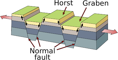
 Subsidence is the lowering of the ground surface. Tectonic subsidence is the lowering of the ground as a result of an earthquake.  While there are subsidence can occur as the result of different types of tectonic actions, generally tectonic subsidence happens when the vertical movement of ground causes nearby ground to lower in relation to it's previous location. This is what can happen with normal faults. In a normal faulting zone, subsidence is evident from the creation of horsts and grabens, raised or lowered blocks of crust. Horst and graben along normal fault zone. USGS image, public domain. A pull-apart basin can be created in a strike-slip fault zone. Strike-slip faults are where the blocks of crust have faults that are vertical, or near vertical, and movement on the fault is usually sideways (horizontally). A pull-apart basin forms when opposing walls of the fault pull apart from each other, resulting in dropped ground. Tectonic subsidence may also occur when loose sedi