# 9 - Utah Earthquake Risk
Easily ranked in the top 10 states with the highest earthquake risk, Utah's primarily risk lies among the Wasatch Fault Zone.
The following image is of a building damaged in the February 2011 Christchurch earthquake in New Zealand. There have been several comparative studies done between New Zealand buildings damaged by earthquakes and similar structures in Utah.

Utah
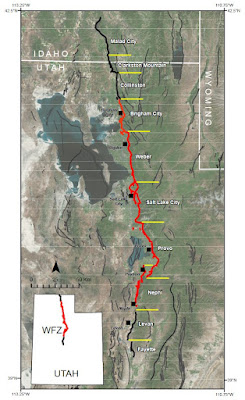
The Wasatch Fault Zone stretches about 240 miles from southern Idaho into northern Utah. While it is the longest fault zone in the area, it’s not the only one. Other large fault zones in the area include the Oquirrh-Great Salt Lake, West Cache, Stansbury, and Eastern Bear Lake fault zones.
The Wasatch Fault is at the base of the mountain range that runs through the state. Along the urban corridor, this section of the mountains is referred to as the Wasatch Front. With many communities built along the foothills, a major seismic rupture could not only cause a lot of liquefaction damage in the lowlands but hundreds of rockslides that could cascade into neighborhoods.
Running north-south along the Wasatch Fault is the main transportation artery, Interstate-15. Interstate-80 runs east-west through the Salt Lake Valley. A large earthquake would virtually shut down most transportation into and through the area.
Throughout Utah, there are more than 200 active faults, and many of these can produce ruptures of magnitude 6.5 to 7.5. While the Wasatch Fault tends to receive the most attention, and it has the highest risk, Utah’s high earthquake risk area extends from the Idaho border on the north down to the Arizona and Nevada borders. Over 95 percent of Utah’s population live within this high-risk zone (Utah's Earthquake Risk?).
With nearly 80 percent of Utah’s population living and working within fifteen miles of the Wasatch Fault and about 75 percent of the state’s economy also in the same area, combined with a large number of buildings susceptible to earthquake damage, there is a very high risk of economic and property loss in the event of a large earthquake.
A 2016 report estimated the probability of a magnitude 6.75 or higher earthquake in the next 50 years at 43 percent, which is much higher than earthquake experts had expected. The Wasatch Fault itself has an 18 percent probability, with other fault zones adding the extra 25 percent risk (Working Group on Utah Earthquake Probabilities, 2016).
In the event of a 7.0-magnitude tremor, it’s estimated that as many as 1 in 3 homes, about 76,000 single-family houses, in Salt Lake County are at risk of major damage or collapse. But residences aren’t the only buildings at risk. In some of the older, historic districts, as many as 9 in 10 brick-and-mortar buildings are built with unreinforced masonry (URM) and are high risk (1 in 3 Salt Lake County homes at greater risk of crumbling in earthquake). Throughout Utah, over 200,000 buildings are constructed with URM, and about 25 percent of the population work, go to school, or live in these buildings. As a comparison, California has about 25,000 URM buildings. These URMs pose a great hazard, and it’s estimated that up to 90 percent of the deaths and injuries in Utah’s next major earthquake will be from damaged or collapsed URMs (My Risk? Every Utahn should know).
In recent recorded history, the two largest earthquakes in Utah were a magnitude 6.6 in Hansel Valley in 1934, and a 6.5-magnitude quake in the town of Richfield in 1901. Two other quakes, although not as large, have occurred since then: a magnitude 5.7 earthquake hit Richmond in 1962, and a 5.8 shook St. George in 1992. These last two smaller-magnitude quakes actually caused more damage (Earthquakes & Utah).


Comments
Post a Comment