Earthquake Risks in the US

 In 2018, the U.S. Geological Survey (USGS) released a report that found 42 of the 50 states have a reasonable chance of experiencing a damaging earthquake over the next 50 years. With the report, they released an updated hazard risk map. The following image is the Simplified 2018 long-term risk map for earthquakes in the United States over the next 50 years. There are more recent short-term risk hazard maps, but as of this writing, the 2018 is the most recent long-term map. As indicated by the colored legend, pink, red, and orange have the higher risk for earthquake damage.

The following hazard map is from the USGS and is in the public domain. Regarding the hazard map, the USGS states:

"Earthquake hazard map showing peak ground accelerations having a 2 percent probability of being exceeded in 50 years, for a firm rock site.  The map is based on the most recent USGS models for the conterminous U.S. (2018), Hawaii (1998), and Alaska (2007).  The models are based on seismicity and fault-slip rates, and take into account the frequency of earthquakes of various magnitudes.  Locally, the hazard may be greater than shown, because site geology may amplify ground motions." 

Hazard map is at from https://www.usgs.gov/media/images/2018-long-term-national-seismic-hazard-map
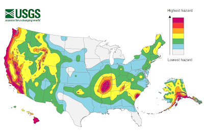
2018 Long-term National Seismic Hazard Map

Earthquake Risk and Hazard

It’s easy to see from the map that the West Coast states, Alaska, and Hawaii are high risk earthquake locations. What about the other states?

Eight states, according to their risk assessment, don’t have significant earthquake hazard levels. These states are Florida, Iowa, Kansas, Louisiana, Michigan, Minnesota, North Dakota, and Wisconsin. From the map, you can see it’s not that these states have no risk, it’s just not a “significant” risk. Most of these states actually have at least some risk. The more probable risk factor is from a large earthquake happening in a nearby state. With shaking and other earthquake-related effects affecting areas hundreds of miles from the epicenter, just about every state has the potential to experience earthquake-related damage. 

The USGS identified 16 states as having the highest earthquake risks. We expect to see California, Alaska, Hawaii, Washington, and Oregon on the list of states with the highest earthquake risk. However, some of the other 11 high risk states might raise some eyebrows. These states are Arkansas, Idaho, Illinois, Kentucky, Missouri, Montana, Nevada, South Carolina, Tennessee, Utah, and Wyoming.

At the other end of the earthquake risk spectrum, Florida and North Dakota have the least number of earthquakes in the United States.

Comments

Popular Posts

Wasatch Fault Earthquake Scenario

Earthquake Hazards: Surface Fault Rupture

San Francisco Earthquake Scenario