Posts

Foreshocks and Swarms

Image
 Other pages have discussed foreshocks as indicators of an impending earthquake.  Foreshocks are often stronger than expected (minor to moderate category), unusual or unexpected earthquakes that occur in or near a high earthquake risk area.  Unfortunately you don't know an earthquake is a foreshock until a bigger quake happens. Earthquake swarms are lots of smaller earthquakes within a geographically small area, usually on or near the same fault line. Like a foreshock, an earthquake swarm could also indicate an impending, larger earthquake. The problem is foreshocks and swarms don’t come with a “prepare for a bigger one” warning.  It's difficult to identify when in the future a bigger earthquake will rupture. Usually quakes identified as a foreshock happen within a few days preceding the main shock. The reality of foreshocks and swarms is it’s hard to definitively state either is an indicator of a larger earthquake until after a larger quake strikes. In other words, ...
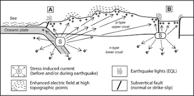
Earthquake Lights

Image
 Earthquake lights (EQL) are phenomena that are sometimes reported in conjunction with an earthquake. These EQL could take the form of balls of light, steady glowing lights, sheet lightning, bluish flames appearing to come out of the ground, or flashes of light similar to lightning except they come from the ground. Usually the EQL is seen before or at the time of the earthquake, near the epicenter area. Because of the rarity of the event, and insufficient evidence to formulate a conclusion, some geophysicists doubt whether there really could be EQL as some of the sightings have been attributed to such things as power lines shaking and arcing. This image is a simplified model of the subduction zone environment and where earthquake lights are likely to be seen. (Image retrieved from https://upload.wikimedia.org/wikipedia/commons/9/9f/How_EQL_form.gif and is attributed to ScienceResearch / CC BY-SA (https://creativecommons.org/licenses/by-sa/4.0) Creative Commons Attribution-Share Ali...

Earthquake Early Warning

Image
People have been trying to predict earthquakes as long as earthquakes have been happening.  Some claim to have dreams or visions that predict an earthquake, but this is a bit unreliable especially pertaining to when and where.  There have been some scientific studies regarding earthquake prediction but these have primarily related to analyzing data that was gathered prior to earthquakes. This is hit and miss because often the data desired was collected because nobody knew it would be needed. And that's the other issue, what data is needed, if it's actually possible to predict earthquakes. A few of the somewhat predictors are foreshocks, earthquake swarms, and possible earthquake lights. These, along with some other promising and interesting studies, warrant their own posts on another day. So, while predicting an earthquake hours or days in advance is still something we'd love to have, there are ways in some parts of the U.S. and other countries that you can get an "adv...

The Longest Earthquake Observed

Image
 2004 Indian Ocean Earthquake For me, the 2004 Indian Ocean Earthquake was the first big earthquake of the 21st century. It occurred on December 25, 2004, about 100 miles (161 km) off the west coast of Sumatra, Indonesia. As an undersea megathrust earthquake, it had a magnitude 9.1-9.3 (depending on what source you refer to) and caused massive tsunamis that flooded coasts around the Indian Ocean. Longest  Earthquake Observed The quake has the distinction of being the third-largest ever recorded by a seismograph, and it was the longest ever observed, lasting from 8.3 to 10 minutes, depending on the station that was recording it. While the earthquake itself didn’t cause much damage, the tsunami waves up to 100 feet (30 m) high killed an estimated 227,898 people in 14 countries. The quake was also believed to have triggered a number of other earthquakes, including some in Alaska.  Here's something I find fascinating. Some seismologists believe the 2002 Sumatra earthquake, w...

Wasatch Fault Earthquake Risk

Image
 The Wasatch Fault is a normal fault, where the Wasatch range mountain block of crust slips mostly vertical, relative to the western, valley-side that has a downward movement. It is the “most studied…normal fault in the world” ( Earthquake Probabilities for the Wasatch Front Region in Utah, Idaho, and Wyoming ).  The fault runs for about 240 miles and has 10 segments. The north end reaches towards Malad City, Idaho, and the southern-most segment extends to Fayette, Utah. Each segment is thought to rupture independent of the others. Because of the multiple segments, the term Wasatch Fault Zone is often used interchangeably with Wasatch Fault. The Wasatch Fault is the most active fault of the seismically active area known as the Intermountain seismic belt, which extends from Montana south to Arizona, and west to Nevada.  The following is an graphic of the Wasatch Fault with its major fault segments along the Wasatch Fault. Wasatch Fault - Central Segments The five central s...

Western Regional Earthquake Risk

Image
 The entire west coast is at high risk for earthquakes. The Insurance Information Institute lists the ten costliest earthquakes in the United States from 1906 through 2018. Of those, six were in California  ( Facts + Statistics: Earthquakes and tsunamis. ).  Earthquake Risks in the West Two other quakes on that list were also on the western end of North America. One quake was a magnitude 6.8 rupture that struck Nisqually, Washington, on February 28, 2001. A magnitude 7.1 shook Anchorage, Alaska, on November 30, 2018. Of the remaining two costliest earthquakes in the U.S., one was a 6.7 rupture on October 15, 2006, in Kiholo Bay, Hawaii. The other was a much smaller, magnitude 5.8 tremor that rocked the Piedmont region of Virginia on August 23, 2011. Returning to the west coast, the USGS puts the probability at 60 percent that a magnitude 6.7 or greater earthquake will strike the Los Angeles area within the next 30 years. Probabilities for magnitude 7 and 7.5 ruptures are ...

Central Regional Earthquake Risk in the U.S.

Image
 December 16, 1811, residents of the small town of New Madrid, Missouri, where awakened by the roar and violent shaking of a large earthquake. It was the first of three large quakes, estimated to be between magnitude 7.5 and 8.0, that shook the area over two months, the last large one striking February 7, 1812. Some sources estimate the highest magnitudes to be 8.7 to 9.2. Residents of the area reported cracks opening, the ground rolling in visible waves, and large areas of ground rose or sunk. Locations as far away as Charleston, South Carolina, and Washington, D.C. reported damage ( New Madrid Seismic Zone ). The December 1811 quake “rang church bells in Boston, Massachusetts, 1,000 miles away” ( Insurance Information Institute, Background on: Earthquake insurance and risk ). There were reports of the Mississippi River flooding, and even running backwards in some locations ( Arkansas Department of Emergency Management, Earthquake ). Other accounts saw the river rise “like a great...